Orthomosaic Mapping Services in South Carolina and Photogrammetry Services in North Carolina
At Halfback Drones, we love making the ordinary extraordinary. Our orthomosaic mapping services in South Carolina and our Photogrammetry services nearby areas give you detailed, high-resolution maps with amazing accuracy and clarity.
Whether you're working in construction, real estate, agriculture, or environmental monitoring, our advanced drone technology captures every detail you need to make smart decisions.
Disclaimer:
I provide mapping services exclusively within the state of South Carolina. Please note that while I may conduct data collection and photogrammetry in North Carolina, no mapping services are offered in that state.
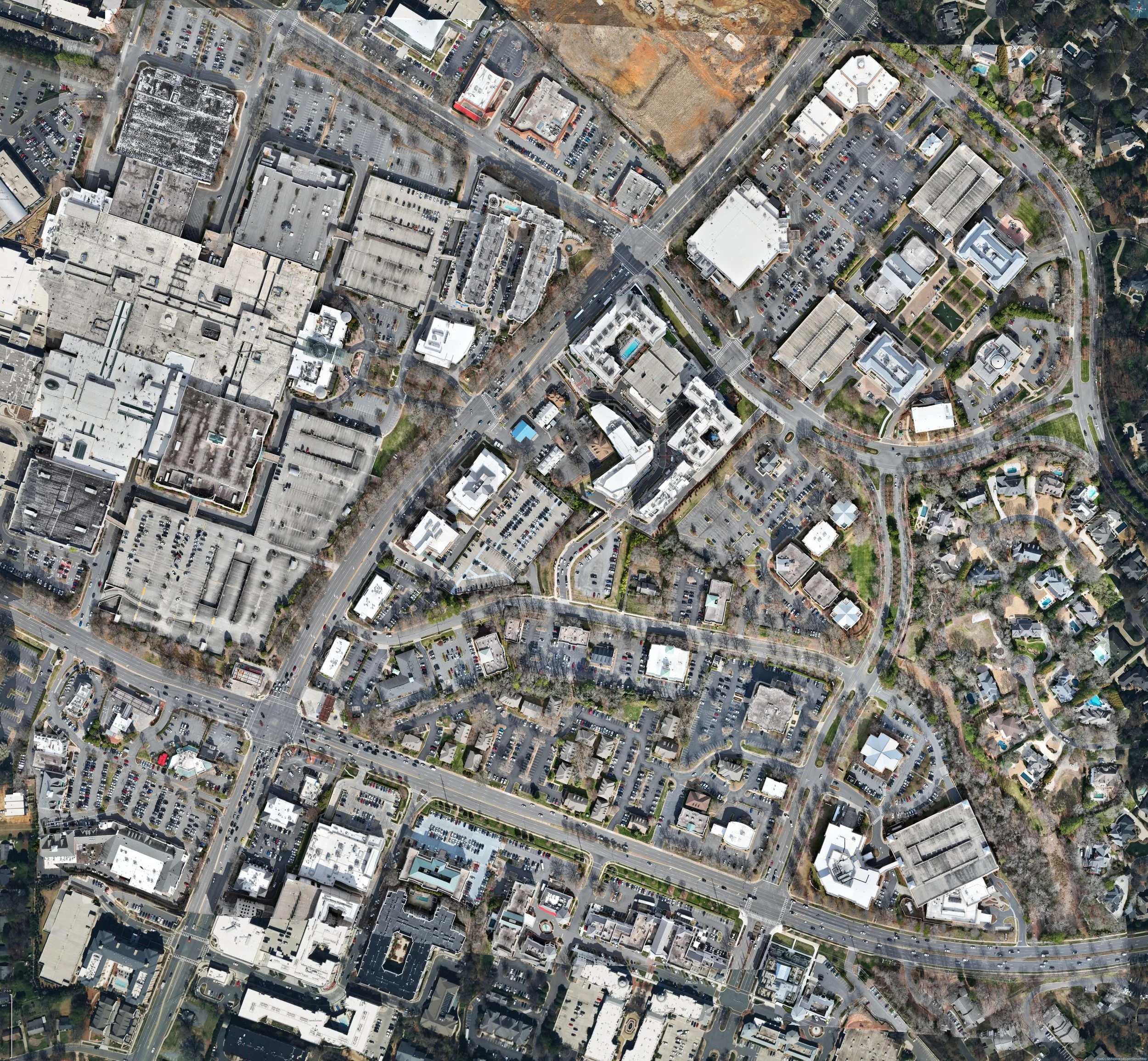
What is Orthomosaic Mapping?
Orthomosaic mapping involves using drones to capture a series of high-resolution aerial photographs. These images are then stitched together using advanced software to create a single, cohesive map that is geometrically accurate and highly detailed.
This technology allows for precise measurements, detailed inspections, and comprehensive analysis of large areas.
What Industries Benefit the Most from Orthomosaic Mapping?
Orthomosaic mapping is a versatile and powerful tool that offers significant benefits to a wide range of industries. Here are some of the key sectors that benefit the most:
Construction
Site Planning and Management: Orthomosaic maps provide detailed, high-resolution images that help in site planning, monitoring progress, and managing resources effectively.
Accurate Measurements: They allow for precise measurements of distances, areas, and volumes, aiding in accurate project estimations and cost management.
Safety and Compliance: Regular mapping can help identify potential safety hazards and ensure compliance with regulatory standards.
Real Estate
Property Marketing: High-quality aerial maps and images enhance property listings, giving potential buyers a comprehensive view of the land and surrounding areas.
Development Planning: Developers use orthomosaic maps for site analysis, planning, and designing new projects, ensuring optimal use of the land.
Property Management: Detailed maps assist in managing large properties, including agricultural lands and commercial estates.
Agriculture
Crop Monitoring: Orthomosaic mapping helps farmers monitor crop health, identify issues such as pest infestations, and optimize irrigation.
Land Management: It provides detailed insights into soil conditions, topography, and land usage, aiding in better farm management practices.
Yield Prediction: Accurate maps help in predicting crop yields and planning harvests more efficiently.
Frequently Asked Questions
What are the benefits of orthomosaic mapping? Orthomosaic mapping provides highly accurate, detailed maps that can be used for a variety of applications, including construction planning, agricultural monitoring, and environmental assessments.
How accurate are the maps? Our orthomosaic maps are incredibly accurate, often down to just a few centimeters. This precision makes them ideal for detailed analysis and measurements.
How long does it take to receive my orthomosaic map? The turnaround time depends on the size and complexity of the area being mapped, but we strive to deliver your maps as quickly as possible, typically within a few days.
Can orthomosaic maps be used for 3D modeling? Yes, orthomosaic maps can be used to create detailed 3D models, providing an even more comprehensive view of the mapped area.
Is orthomosaic mapping suitable for large areas? Absolutely. Orthomosaic mapping is perfect for large areas, as drones can cover significant ground quickly and efficiently, capturing detailed images throughout.
How do I get started with Halfback Drones? Getting started is easy! Simply contact us to discuss your project, and we’ll work with you to develop a customized plan that meets your needs.